Pages

Isola Bella,Italy

Isola Bella,Italy
Isola Bella,Italy

Isola Bella is one of the Borromean Islands of Lake Maggiore in northern Italy. Lake Maggiore is the second largest lake in all of Italy, with its northernmost point crossing over into Switzerland. The island of Isola Bella is located in the Borromean Gulf nearest to the town of Stresa. The island is a mere 320 meters long by 400 meters wide, and predominantly occupied by the Palazzo Borromeo and its terrace garden.

Until the early 17th century the island was little more than a small fishing village, but in 1632 the powerful Carlo III of the House of Borromeo began building a palazzo there named for his wife, Isabella D'Adda. Mid-century the construction plans were sidetracked by a terrible outbreak of the plague. Ownership of the island then transferred to Carlo's sons, who worked with architect Carlo Fontana to create not just a simple villa but a palace worthy of entertaining the greatest nobility of Europe. The gardens were not completed until 1671.
During the period of Giberto V Borromeo (1751-1837), Isola Bella would achieve its highest societal importance hosting such guests as Napoleon and his wife Joséphine, and Caroline of Brunswick, the Princess of Wales. Today, the island is maintained as a popular tourist destination, where one can explore the magnificent palazzo and its gardens, as well as shop in small boutiques and dine on tempting Italian and European cuisine.


Isola Bella means beautiful island and this little island in Taormina, Italy fully justifies the name. The island is filled with colors and with every passing season the colors keep changing, and behold, one ravishing landscape after another for the onlookers to enjoy. It is also known as the Pearl of the Ionion Sea. The rocky beach of the small inhabited island attracts sunbathers and hikers every year. It also attracts snorkelers and  has a Nike Dive Center where they teach different diving techniques. The pretty island is definitely worth a visit.

World's Best Picnic Spots


1.Huayna Picchu, Peru
At an elevation of nearly 9,000 feet, the view from atop this peak, which towers over the 15th-century ruins of Machu Picchu, is breathtaking in a number of ways. A steep, slippery climb to this rocky summit is a nerve-racking effort—one instantly rewarded with a panoramic perspective of the Urubamba River Valley and the famed city of the Inca. But what to eat? Certainly not a complicated dish of roasted cuy (guinea pig) or a pisco sour. Instead, a celebratory Inca Kola and a pleasantly portable butifarras—a sandwich of Peruvian ham, onions, chili peppers, and lime. Don't linger too long—the hike down is a doozy.

Huayna Picchu also known as Wayna Picchu (Quechua: "Young Peak") is a mountain in Peru around which the Urubamba River bends. It rises over Machu Picchu, the so-called "lost city of the Incas" and divides it into sections. The Incas built a trail up the side of the Huayna Picchu and built temples and terraces on its top. The peak of Huayna Picchu is about 2,720 metres (8,920 ft) above sea level, or about 360 metres (1,180 ft) higher than Machu Picchu.
According to local guides, the top of the mountain was the residence for the high priest and the local virgins. Every morning before sunrise, the high priest with a small group would walk to Machu Picchu to signal the coming of the new day. The Temple of the Moon, one of the three major temples in the Machu Picchu area, is nestled on the side of the mountain and is situated at an elevation lower than Machu Picchu. Adjacent to the Temple of the Moon is the Great Cavern, another sacred temple with fine masonry. The other major local temples in Machu Picchu are the Temple of the Condor, Temple of Three Windows, Principal Temple, "Unfinished Temple", and the Temple of the Sun, also called the Torreon.
 
Machu Picchu at Sunrise  

Machu Picchu’s cascading terraces and precision-cut stones provide evidence of the masterful building skills of the Inca, whose empire included a vast realm of 12 million people at its height.


Stone Wall 

Mountains rise above stone walls at Machu Picchu, which served as a royal retreat. The Inca quarried and moved stones weighing more than a hundred tons despite lacking wheeled vehicles and iron tools.


Tourists, Huayna Picchu


Visitors to Machu Picchu take in the view from Huayna Picchu, the peak that looms over the Inca site. The Urubamba River cuts through the valley below.

Stone Structures


According to Hiram Bingham, who uncovered and excavated the site during an expedition in 1912, the quality of the stonework at Machu Picchu dwellings reflected the status of their residents.


Urubamba River Gorge


The Urubamba River is seen below terraces carved into a ridge at Machu Picchu. The rich soil of the Urubamba River Valley continues to support the high-yield varieties of corn developed by the Inca.


Machu Picchu


Hiram Bingham was a 35-year-old assistant professor at Yale University when he set out from a camp on the Urubamba River to investigate reports of ruins on a towering ridge known as Machu Picchu (“old mountain” in the Inca language). What he found was an Inca ghost town that had been hidden from the outside world for nearly 400 years.


Huayna Picchu Terraces


Terraces are carved high on Huayna Picchu. For decades Machu Picchu was a puzzle for archaeologists and historians. A 16th-century legal document and studies of the site’s architecture and artifacts in the latter 20th century have suggested a mountaintop retreat for Inca ruler Pachacutec Inca Yupanqui.


Vietnam Beaches Tour

Vietnam Beaches Tour

Vietnam Beaches Tour
There are numerous beaches along the read Vietnamese coast. A beach vacation in thecountry is to be an unforgettable experience with white sand, crystal clear water anddelicious selection of seafood. The best beach vacation will depend on the individual's personal choice.
Nha Trang is the top choice for a seaside holiday location Vietnam. The Ocean City forhis trips to exotic islands is known diving and delicious seafood dishes. A tour of the city of Ho Chi Minh is also an option during his holiday in Nha Trang.

North Vietnamese Bai Chay Beach is visited often, especially during summer weekends.Near the capital, Hanoi, Bai Chay Beach is worth a visit if tourists do not have time for a longer holiday by the sea.
Halong Bay is home to many islands that have some excellent beach locations and isalso near Hanoi. The beaches are found on the islands a few good options, kayaking,that want to explore the visitor.
Some other popular beaches in Vietnam include Vung Tau, which is very popular with the residents of Ho Chi Minh City. Located just a few hours drive from Ho Chi Minh City, thebeaches of Phan Thiet and Mui Ne, which are not visited very often, but are still very nice.Some lovely four-star hotels and a golf course in Phan Thiet are other reasons to visit this rather quiet beaches in Vietnam.

Great Wall of China

Great Wall of China
万里长城

UNESCO World Heritage Site 


The Great Wall of China is a series of fortifications made of stone, brick, tamped earth, wood, and other materials, generally built along an east-to-west line across the historical northern borders of China in part to protect the Chinese Empire or its prototypical states against intrusions by various nomadic groups or military incursions by various warlike peoples or forces. Several walls were being built as early as the 7th century BC; these, later joined together and made bigger, stronger, and unified are now collectively referred to as the Great Wall.Especially famous is the wall built between 220–206 BC by the first Emperor of China, Qin Shi Huang. Little of that wall remains. Since then, the Great Wall has on and off been rebuilt, maintained, and enhanced; the majority of the existing wall was reconstructed during the Ming Dynasty.

Other purposes of the Great Wall have included border controls, allowing the imposition of duties on goods transported along the Silk Road, regulation or encouragement of trade and the control of immigration and emigration. Furthermore, the defensive characteristics of the Great Wall were enhanced by the construction of watch towers, troop barracks, garrison stations, signaling capabilities through the means of smoke or fire, and the fact that the path of the Great Wall also served as a transportation corridor

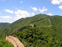
The Great Wall stretches from Shanhaiguan in the east, to Lop Lake in the west, along an arc that roughly delineates the southern edge of Inner Mongolia. A comprehensive archaeological survey, using advanced technologies, has concluded that the Ming walls measure 8,850 km (5,500 mi). This is made up of 6,259 km (3,889 mi) sections of actual wall, 359 km (223 mi) of trenches and 2,232 km (1,387 mi) of natural defensive barriers such as hills and rivers. Another archaeological survey found that the entire wall with all of its branches measure out to be 21,196 km (13,171 mi).

Who, When and Why Built the Great Wall of China?
Who built the Great Wall? There are many answers. Some say Emperor Qin Shihuang. Some say ordinary working people of ancient China, and some say that it was slaves who built the wall. This is not an easy question to answer, just like the wall was not easy to build. 

Experts have given us the most credible answer. As early as the Warring States Periods (476 BC - 221 BC), the ruling powers began to build walls as a defense against the northern nomadic tribes and other potential enemies. The state of Chu (11th Century BC-223BC) was the first to build a wall, followed by the Qi, Yan, Wei, Zhao and Qin. After Emperor Qin Shihuang unified the six states, he ordered General Meng Tian to connect the existing walls and to extend them further as a front line defense against possible invasion. Thus the Great Wall of China was formed. It extended from Lintao (present Lintao County in Dingxi City in Gansu Province) in the west and ended at Liaodong (present the eastern and southern parts of Liaoning Province) in the east. It was called "Wan Li Chang Cheng" (The Long Wall of 10,000 Li).

Three groups of people built the wall. They were soldiers, common people and criminals. Many people died during its construction, due to the heavy work, short time limit and tough condition. An accurate number of those who died is unknown. 


During subsequent dynasties, the wall was extended, repaired or modified. The section of wall built in Han Dynasty (206BC-220) is the longest. During the Ming Dynasty (1368-1644), the wall was substantially repaired on more than twenty occasions. Today, the best known and most visited sections of the wall are at Badaling, Mutianyu, Simatai and Jinshanling and these were built in the Ming Dynasty. They were all built to protect the people and territories south of the wall from a continued threat of invasion by the northern nomadic tribes.

Can the Great Wall Be Seen from the Space?


Measuring about 8,851.8 km (5,500 miles) long, the Great Wall is no doubt the longest manmade project on the earth. It was once widely believed that it can be seen from the space. Many astronauts have verified this saying and taken photos as evidence. Some medium even reported with affected seriousness, "The biggest building the astronauts could see from the space is the Great Wall, which looks very much like a black worm." Consequently, this statement has gone deep into people's minds and become a great honor that Chinese people enjoyed for years.

Is the Great Wall truly visible from the moon? Yang Liwei, China's first astronaut who was lifted into the outer space by the spacecraft Shenzhou V on Oct.15, 2003, gave a definite answer "No" to a reporter after he reached the ground. Yang's negative response in a practical way may probably put out a fair number of people's passion. But it powerfully corrected the misconception. Great Wall is indeed great, but you won't see it from the space!

In fact, besides Yang Liwei, there are a lot of astronauts said the Wall could not be seen from the space. Neil Alden Armstrong, the American aviator who first set foot on the moon in 1969, was asked a thousand times whether or not he had seen the Great Wall from the moon. Recently from a sound recording that announced by NASA Johnson Space Center, Armstrong said that he had seen the continent, lakes and blue spots touched with red. But he could not make out any manmade object on the earth from the moon

 Great Wall Sections:
The Wall we see today was mostly built during the Ming Dynasty (1368 - 1644). It starts from Hushan in the east to Jiayuguan Pass in the west traversing Liaoning, Hebei, Beijing, Tianjin, Shanxi, Inner Mongolia, Ningxia, Shaanxi, Gansu and Qinghai. Here lists the famous sections for you to know the incredible diversity of scenery along the wall and practical travel tips.
 Badaling  Gubeikou  Huanghuacheng
 Huangyaguan  Jiankou  Jiayuguan
 Jinshanling  Juyongguan  Mutianyu
 Shanhaiguan  Simatai  Yangguan
 Yanmenguan  Yumenguan  Zhenbeitai
Great Wall History
 The history of the Great Wall is said to start from the Spring and Autumn Periods when seven powerful states appeared at the same time. In order to defend themselves, they all built walls and stationed troops on the borders. At that time, the total length of the wall had already reached 3,107 miles, belonging to different states.

In 221 BC, the Emperor Qin absorbed the other six states and set up the first unified kingdom in Chinese history. In order to strengthen his newly born authority and defend the Huns in the north, he ordered connecting the walls once built by the other states as well as adding some sections of his own. Thus was formed the long Qin's Great Wall which started from the east of today's Liaoning Province and ended at Lintao, Gansu Province.

In the Western Han Dynasty, the Huns became more powerful. The Han court started to build more walls on a larger scale in order to consolidate the frontier. In the west, the wall along the Hexi corridor, Yumenguan Pass, and Yangguan Pass was built. In the north, Yanmenguan Pass and Niangziguan Pass in Shanxi were set up. Many more sections of the wall extended to Yinshan Mountain and half of the ancient Silk Road was along the Han's wall.

The Northern Wei, Northern Qi and Northern Zhou Dynasties all built their own sections but on a smaller scale than the walls in the Han Dynasty. The powerful Tang Dynasty saw peace between the northern tribes and central China most of the time, so few Great Wall sections were built in this period.
Great Wall Construction
The history of the construction of the Great Wall of China can be dated back to the Western Zhou Dynasty (11th century BC - 771 BC). But the Great Wall at that time was only a line of fortresses standing to defend against attacks from the Yanyun (an ancient nomadic tribe in north China). The Period of the Warring States (476 BC - 221 BC) was an era when the seven states (Qi, Chu, Yan, Han, Zhao, Wei, Qin) were busy engaging in Great Wall construction for self-defense. Instead of one line, their walls stretched in the four directions and varied in length from several hundred miles to one or two thousand miles.

In the Qin Dynasty (221 - 206 BC) the emperor Qin Shihuang ordered his laborers to connect these scattered walls and create some new sections, thus forming a Great Wall in northern and central China in the true sense. The Ming Dynasty (1368 - 1644) further developed the defensive system of the wall and strengthened it on a larger scale. It pushed the wall construction to its highest peak.


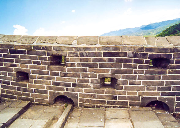
Battlement Wall with Loopholes
The winding Great Wall is not merely a wall but instead a complete and rigorous defense project composed of countless passes, watchtowers, garrison towns, beacon towers and blockhouses.  These fortifications were arranged in certain ways under the control of the military command system at all levels. For example, there were about 1,000,000 soldiers guarding the Ming's Great Wall. The chief military officers were stationed in garrison-towns, while lesser officials and soldiers were stationed in Guan Cheng (the defensive beachhead) and other smaller fortifications. The eleven Great Wall garrisons were set up along the Great Wall in order to guard the precinct or subsection.

The average height of the Ming Great Wall measures 33 feet and the width is about five yards. In low, flat areas the Great Wall was built high and more defense lines were added. In the lofty mountains, the wall was a little lower in order to save the human and financial cost. Sometimes, even steep cliffs served as natural walls to thwart enemies.

Today, the Great Wall has lost its military function, but as a great ancient engineering work, its magnificent beauty and austere structure are still worthy appreciating.

Great Wall of China
万里长城

The Great Wall

Map of all the wall constructions
General information
TypeFortification
Country China
Coordinates40.67693°N 117.23193°ECoordinates: 40.67693°N 117.23193°E
Construction started7th century BC
Technical details
Size21,196 km (13,171 mi)

UNESCO World Heritage Site
Official name: The Great Wall
Type:Cultural
Criteria:i, ii, iii, iv, vi
Designated:1987 (11th session)
Reference #:438
State Party:China
Region:Asia-Pacific

Top 5 Best Vacation Spots in Mediterranean


Top 5 Best Vacation Spots in Mediterranean


1-Turkey, the country of the Fairs
Its special geographical position, Turkey is a unique country. The majority (Anatolia) is inAsia and the rest (Tharcië) in Europe. Thus, Turkey is a melting pot of cultures. The country has both modern and historic cities. In the city of Istanbul, you can create a longon the wide boulevards and stroll. Turkish women parading in miniskirts and high heelsmiss you. Ultra-modern shopping malls, streets with hundreds of small businesses to cover. For the true shopper's paradise Grand Bazaar is the highlight. Here you will findmany articles have covered in a maze of narrow streets. Shop 'till you drop! Istanbul is a stark contrast to the areas in the center of Turkey. 
The pristine nature take authenticvillages and magnificent monuments you back in time 100 years. Even the houses inside are all the attractions. Conical and cubic houses of clay, tuff carved houses and colorfuldecorations for your eye pass. A property that you trade anywhere in Turkey. Both inmodern cities and in small villages keeps you engaged in the industry. You can not thinkof the Turks, or to sell, under the porch of her booth. They are very clever andsophisticated in their profession, as a tourist, but let's not be fooled. It belongs to everyone, because the game of bargaining.
2-A varied holiday in Greece
A varied holiday in Greece

Island hopping, or explore the mainland, Greece is the land of opportunity. The country offers many unique attractions. In particular, the capital of Athens is a paradise for loversof cultural monuments. The Acropolis is the most famous ruins and is the symbol of thisstad.De lake is the oracle of Apollo Delphi. It is located in a beautiful setting where youcan have many other archaeological finds are discovered. Tired of the mainland?Explore one of the 150 islands belong to Greece. The best known and most visited Crete and Rhodes. Crete is characterized by extensive vineyards and olive groves, orange.Because of its rich history and beautiful beaches of the island is popular with holidaymakers. Rhodes can not be completely missed. The island was declared aUNESCO world heritage monument. The mainland and the islands, Greece has manypossibilities for a varied holiday!
3-Passion in Italy
Passion in Italy

La familia, pasta, pizza, olive trees and passion are the ingredients of Italy. But eachregion has its own specialties and characteristics. The north is dominated by large citiessuch as Milan and Venice and is the most densely populated of all. In the center you will find one of the most beautiful provinces of Tuscany. The many vineyards, olive grovesand lavender fields around this area a beautiful landscape. The typical Italian cities like Florence, Siena and Pisa are the main attractions and are well worth a visit. Southern Italy is also known as "naked south" called, is known. The primitive existence has lived here for some time. Here you will find a lot of wild nature and the traditional white villages.Those who want to experience the real South, you can access the Gargano peninsula.Last but not least the magnificent Rome. Days you wander through the narrow streets, admire the remains of the Roman era and enjoy the delicious food. Probably part after a visit to this country have the same passion for Italy, as the Italians themselves.
4-Viva la Spain
Viva la Spain

Mediterranean life of Spaniards speak to many tourists, and this makes Spain one of the most visited countries in the world. Here you will find a wide variety of culture and nature.In Galicia, you can enjoy the wild scenery, the La Rioja wine region-wide and beautifulbeaches marked on the Mediterranean coast is still heavily visited. Who wants to goconsiderably out of his sphere, you can access the islands of Majorca and Ibiza. For those who's authentic culture and keeps the interior is an ideal starting point. Here youwill find many old, white villages, churches and hills. The temperament of the Spaniard ismainly found in the famous Spanish flamenco and bullfighting. For tourists, a bull's pretty shocking, but remember that just belongs to the Spanish culture. Those who want to dipbelow this should definitely visit one of the many arenas. In addition to rest in this beautiful country than anything else under the sun of the best Spanish wines, tapas andenjoy!
5-France, the ultimate destination for everyone
France, the ultimate destination for everyone

Paris, the French champagne magical Disney Land and the French Cote d'Azur. It's no coincidence that France remains one of the most popular holiday destinations in the Netherlands. The main attraction is of course Paris. You can already nibbling at your French baguette on the Champs-Elysées parade, you have immortalized by one of themany portrait painters in Montmartre or the top of the Eiffel Tower to enjoy the beautiful view. If you want something more to get French culture and nature, certainly must visit the interior. Here you will find picturesque villages where old men nice game of boules. Forbeach lovers, the French Cote d'Azur is the perfect place to enjoy the sun. Large resorts like Nice and Cannes, offer a lot of sun, sea and beach entertainment. The Spanish border, you find the Pyrenees, with all its mountains, lakes and hundreds of wild water is a paradise for adventurers. France is a country where young and old feel at home, the ultimate destination for all!

SANGANO BAMBOO FOREST, JAPAN

SANGANO BAMBOO FOREST, JAPAN
,SANGANO BAMBOO FOREST, JAPAN

Every now & then they yearn for a pretty natural landscape filled with plenty of greenery for taking a walk. They love holding hands & jogging miles to say what is in our hearts or to basically enjoy the scenic surroundings & bask in the glory of a loving relationship. If this sounds familiar then this location would be a heaven for you & your better half. This bamboo forest in Japan is of the oldest & as legend would have it when Edison was looking for a filament for his first bulbs,the Governor recommended this forest & another. Edison selected the other though.

Sardar Sarovar Dam , Gujarat

NARMADA - The lifeline of Gujarat 

The Sardar Sarovar Dam is a gravity dam on the Narmada River near Navagam, Gujarat, India. It is the largest dam and part of the Narmada Valley Project, a large hydraulic engineering project involving the construction of a series of large irrigation and hydroelectric multi-purpose dams on the Narmada River. The project took form in 1979 as part of a development scheme to increase irrigation and produce hydroelectricity.
It is the 30th largest dams planned on river Narmada, Sardar Sarovar Dam (SSD) is the largest structure to be built. It has a proposed final height of 163 m (535 ft) from foundation.The project will irrigate more than 18,000 km2 (6,900 sq mi), most of it in drought prone areas of Kutch and Saurashtra. The dam's main power plant houses six 200 MW Francis pump-turbines to generate electricity and afford a pumped-storage capability. Additionally, a power plant on the intake for the main canal contains contains five 50 MW Kaplan turbine-generators. The total installed capacity of the power facilities is 1,450 MW. Critics maintain that its negative environmental impacts outweigh its benefits. It has created discord between its government planners and the citizens group Narmada Bachao

Narmada Canal

The dam will irrigate 17,920 km2 (6,920 sq mi) of land spread over 12 districts, 62 talukas and 3393 villages (75% of which is drought-prone areas) in Gujarat and 730 km2 (280 sq mi) in the arid areas of Barmer and Jalore districts of Rajasthan. The dam will also provide flood protection to riverine reaches measuring 30,000 ha (74,000 acres) covering 210 villages and Bharuch city and a population of 400,000 in Gujarat.

narmada dam over flow


 Sardar Sarovar Dam image in hd


Project at a Glance:
  • Estimated Cost - Rs. 392.4 billion (8 billion USD)
  • Main Dam - 1,210 m long, 163 m high from the deepest foundation level
    • World's Second Largest Concrete Gravity Dam (by volume) after Grand Coulee
    • World's Third Highest Spillway discharging capacity - 87,000 m3/second
  • Designed Live Storage Capacity of the Reservoir 5860 MCM (4.75 million acre feet)
  • Hydropower - 1,450 MW installed capacity (1 billion kWh every year)
  • Irrigation - 1.905 million Ha (1.8 million Ha. in Gujarat benefitting 1 million farmers)
  • Drinking Water - 9633 villages and 131 towns (29 million people)
  • Canal Network - 75,000 km length
    • Main Canal - 458.318 km long, capacity 1,133 m3/second, 633 structures
  • No. of Employees – 4673


Sardar Sarovar Dam

The Sardar Sarovar Dam,
partially completed in August 2008
Sardar Sarovar Dam is located in Gujarat
Location of Sardar Sarovar Dam
CountryIndia
LocationNavagam, Gujarat
Coordinates21°49′49″N 73°44′50″ECoordinates,21°49′49″N 73°44′50″E
StatusOperational
Owner(s)Narmada Control Authority
Dam and spillways
Type of damGravity, concrete
Height (foundation)163 m (535 ft)
Length1,210 m (3,970 ft)
ImpoundsNarmada River
Spillway capacity84,949 m3/s (2,999,900 cu ft/s)
Reservoir
Capacity9,500,000,000 m3 (7,701,775 acre·ft)
Active capacity5,800,000,000 m3 (4,702,137 acre·ft)
Catchment area88,000 km2 (34,000 sq mi)
Surface area375.33 km2 (144.92 sq mi)
Normal elevation138 m (453 ft)
Reservoir length214 km (133 mi)
Max. reservoir width16.10 km (10.00 mi)
Power station
Operator(s)Sardar Sarovar Narmada Nigam Limited
Commission dateJune 2006
TurbinesDam: 6 x 200 MW Francis pump-turbine
Canal: 5 x 50 MW Kaplan-type
Installed capacity1,450 MW